Lab 5
Goal
The goal of this Lab is to produce a geodatabase that will be utilized in the Final Project.
Methods
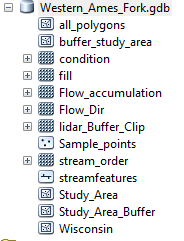
The process for creating the geodatabase is fairly simple for my project. The data base contains data for the western fork of the Pecatonica river watershed in the western fork of the Ames river.The purpose of the geodatabase is to contain all useful outputs when running a model for watershed delineation and stream delineation, and it will also contain point and polygon feature datasets which contain digitized information. Someone would be able to use this geodatabase to gather watershed areas, there is also data that contains Bankfull widths of streams. The data could be useful in a later study to see if Agricultural affects do affect stream systems in western Wisconsin. The Geodatabase is projected to NAD_1983_UTM_Zone_15N, this is the transvers4e Mercator projection for this sliver of western Wisconsin. No topology or annotations were included. Meta data will contain Lidar imagery data, and data that I obtained to perform digitizing and delineation of watersheds and streams. Data that is included is raster outputs that are created from my Lafayette county DEM. additionally point and line features are included in the database. A feature dataset called all polygons is in there and the attributes contain the specific ID that relates to each sample point. Sample points are another feature dataset, and this field contains bankfull width data in meters, that will be utilized later in a regression analysis between drainage area, and bankfull width.
Results
Sources
Lafeyette county Wi DEM
The goal of this Lab is to produce a geodatabase that will be utilized in the Final Project.
Methods
The process for creating the geodatabase is fairly simple for my project. The data base contains data for the western fork of the Pecatonica river watershed in the western fork of the Ames river.The purpose of the geodatabase is to contain all useful outputs when running a model for watershed delineation and stream delineation, and it will also contain point and polygon feature datasets which contain digitized information. Someone would be able to use this geodatabase to gather watershed areas, there is also data that contains Bankfull widths of streams. The data could be useful in a later study to see if Agricultural affects do affect stream systems in western Wisconsin. The Geodatabase is projected to NAD_1983_UTM_Zone_15N, this is the transvers4e Mercator projection for this sliver of western Wisconsin. No topology or annotations were included. Meta data will contain Lidar imagery data, and data that I obtained to perform digitizing and delineation of watersheds and streams. Data that is included is raster outputs that are created from my Lafayette county DEM. additionally point and line features are included in the database. A feature dataset called all polygons is in there and the attributes contain the specific ID that relates to each sample point. Sample points are another feature dataset, and this field contains bankfull width data in meters, that will be utilized later in a regression analysis between drainage area, and bankfull width.
Results
Sources
Lafeyette county Wi DEM


Comments
Post a Comment